About New Zealand (NZ) Topo Map
Topographic map of New Zealand with no limitations: • View and cache topographic tiles and satellite imagery • Download all topographic tiles in a visible region (for offline availability)
Topographic map of New Zealand with
no limitations:
• View and cache topographic tiles and satellite imagery
• Download all topographic tiles in a visible region (for offline availability)
• Add unlimited map markers
• Import GPX / KML / FIT waypoints, tracks and routes
• Record routes (export and share)
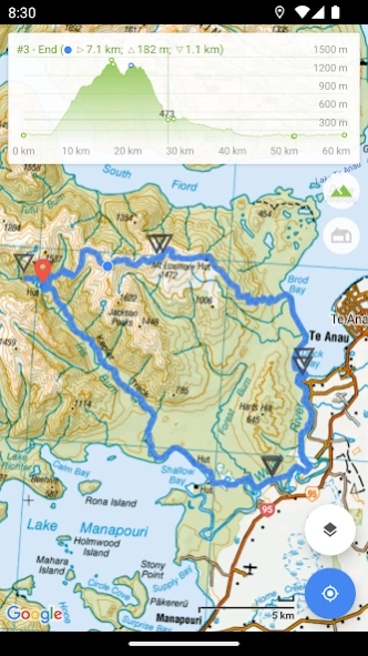
• View track / route elevation profile (with interactive graph)
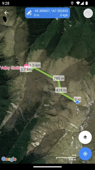
• Measure distance (in a straight line) between multiple points and markers
• Search for places of interest (supports decimal and NZTM2000 coordinates)
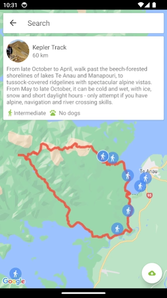
• Search and view DOC huts (tap a hut marker for more information)
• Search and view DOC tracks (import tracks for offline availability)
• Topographic imagery for Antipodes, Auckland, Bounty, Campbell, Chatham, Kermadec and Snares Islands
• Displays the marker paper map reference (when viewing NZTM2000 coordinates)
• Group markers by tag for easy organisation (change colours, toggle visibility)
• Battery conscious (for those that can't recharge every day)
• Space conscious (for those that don't have gigabytes to spare; external SD card support; full tile cache control)
• Stay up-to-date with the latest imagery (no dependency on application updates)
• Navigate with Google Maps interactions (pinch zoom, scroll, rotate, drop marker, drag marker etc)
•
Fully functional for free!
New Zealand (NZ) Topo Map is intended for outdoor enthusiasts who want to mark locations visited, create markers to visit, follow imported tracks or create their own. It's designed to be lightweight, intuitive, responsive, battery conscious and totally free. Perfect for casual day trips to serious bush excursions.
Developed by an adventurous Kiwi for adventurous Kiwis!
Topographic Map Tiles
The Topo50 map series provides topographic mapping for the New Zealand mainland and Chatham Islands at 1:50,000 scale.
At a scale of 1:50,000, Topo50 maps show geographic features in detail. They are useful for a wide range of activities such as local navigation by vehicle or on foot, locality area planning and study of the environment. Used by a wide variety of groups, Topo50 is the official topographic map series used by New Zealand emergency services.
To produce our Topo50 maps of the New Zealand mainland we use:
• The New Zealand Geodetic Datum 2000 (NZGD2000) – the coordinates of longitude and latitude
• The New Zealand Transverse Mercator 2000 (NZTM2000) projection – this is what enables the curved mathematical surface approximating the Earth to be represented on a flat sheet of paper.
To produce our Topo50 maps of the Chatham Islands we use the Chatham Islands Transverse Mercator 2000 (CITM2000) projection.
Topo50 map tiles sourced from the LINZ Data Service http://data.linz.govt.nz/ and licensed by LINZ for re-use under the Creative Commons Attribution 3.0 New Zealand licence.
Satellite Imagery
LINZ has been working towards getting New Zealand’s most current publicly-owned aerial imagery – covering 95% of the country.
Aerial imagery is captured from airborne sensors and cameras. It provides an accurate photographic representation of the earth’s surface and the features on it. It can be used to visualise landscape, or to understand how an area has evolved over time.
Sourced from the LINZ Data Service and licensed for re-use under the Creative Commons Attribution 3.0 New Zealand licence (http://www.linz.govt.nz/data/licensing-and-using-data/attributing-aerial-imagery-data)
Previous Versions
Here you can find the changelog of New Zealand (NZ) Topo Map since it was posted on our website on 2016-11-05 11:58:31.
The latest version is 7.6.3 and it was updated on 2024-04-19 17:31:09. See below the changes in each version.
New Zealand (NZ) Topo Map version 7.6.3
Updated At: 2024-04-12
Changes: • View DOC tracks on a map (tap a track or search for more information)
• Bug fixes and UI improvements
More feature requests coming soon!
New Zealand (NZ) Topo Map version 7.5.0
Updated At: 2024-03-25
Changes: • Confirm markers on long press (feature request)
• Reverse track direction
• Bug fixes and UI improvements
More feature requests coming soon!
New Zealand (NZ) Topo Map version 7.4.4
Updated At: 2024-03-04
Changes: • Elevation graph point selection now shows distance (feature request)
• Elevation graph dual point selection support (feature request)
• Separate settings for imperial distance and elevation (feature request)
• Bug fixes and UI improvements
More feature requests coming soon!
New Zealand (NZ) Topo Map version 7.4.3
Updated At: 2024-02-23
Changes: • Elevation graph point selection now shows distance (feature request)
• Elevation graph dual point selection support (feature request)
• Separate settings for imperial distance and elevation (feature request)
• Bug fixes
More feature requests coming soon!
New Zealand (NZ) Topo Map version 7.3.6
Updated At: 2024-02-02
Changes: • Bug fixes and performance improvements
More feature requests coming soon!
New Zealand (NZ) Topo Map version 7.3.4
Updated At: 2024-01-09
Changes: • Bug fixes, performance and UI improvements
More feature requests coming soon!
New Zealand (NZ) Topo Map version 7.3.3
Updated At: 2023-12-13
Changes: • Bug fixes and UI improvements
More feature requests coming soon!
New Zealand (NZ) Topo Map version 7.3.1
Updated At: 2023-11-29
Changes: • Disable / enable zoom to marker on tap (feature request)
• Bug fixes and UI improvements
More feature requests coming soon!
New Zealand (NZ) Topo Map version 7.2.0
Updated At: 2023-11-13
Changes: • Dedicated zoom controls (feature request)
• Snapshot from track info (feature request)
• Bug fixes, performance and UI improvements
More feature requests coming soon!
New Zealand (NZ) Topo Map version 7.1.1
Updated At: 2023-10-24
Changes: • View and import DOC tracks
• Bug fixes, performance and UI improvements
More feature requests coming soon!
Disclaimer
Official Google Play Link
We do not host New Zealand (NZ) Topo Map on our servers. We did not scan it for viruses, adware, spyware or other type of malware. This app is hosted by Google and passed their terms and conditions to be listed there. We recommend caution when installing it.
The Google Play link for New Zealand (NZ) Topo Map is provided to you by apps112.com without any warranties, representations or guarantees of any kind, so access it at your own risk.
If you have questions regarding this particular app contact the publisher directly. For questions about the functionalities of apps112.com contact us.